Showing posts with label Australia. Show all posts

Monday, August 17, 2009

Wholesale Therapy

Big news today: Costco opened its first Australian warehouse in Melbourne today! That’s right, the American institution of purchasing stuff in packs of 50 right off the shipping pallet, all under an expansive industrial roof, has finally reached across the Pacific to this corner of the world. I know they have locations in Taiwan, Korea and Japan, but as arguably the most Americanized countries in the Asia-Pacific region, it is high time for Australia to finally have a Costco.

For people who are not familiar with Costco, it is a completely different shopping experience than any other place. The biggest difference is that it has done away with the whole pretense of presentation: aisles are flanked not by shelves, but by pallets on which items on offer are shipped. The whole place is a steel-and-concrete warehouse; there’s no pop Muzak playing in the background and no shop assistants helping you trying on the shirt you want to buy. What you see is what you get. Items range from clothes to diapers, from groceries to pet food, from toiletries to cleaning supplies. You won’t find fifty varieties of canned tuna, but what you do find comes in packs of thirty. Want to get some toothpaste? There are packs of five on sale. Toilet paper? How about the packs of fifty? Want some apples? They have 10-lb bags. The big draw is that, per item, the prices are usually quite a bit lower than what one can find in retail shops. Obviously, you don’t go to Costco to pick up some bread and milk, because you will invariably come out with a hundred other things and $300 poorer. It is a boon for budget-conscious and well-disciplined people, heaven on earth for hoarders, but a giant sink hole for the impulsive shopper.

Now, Australians, or rather Melbournians, at least for now, will be able to stock up on a year’s supply of toilet paper and laundry detergent in just one trip. Apparently, there was a two-hour wait for the checkout today. People everywhere just love a bargain.

I wonder when they will open one up in Sydney.

Thirty-roll packs of toilet paper on sale at the Livermore, California, Costco. I had this picture taken to show my friends in Australia because I didn’t think they would ever see such a sight.

Monday, July 27, 2009

Clothes Lines

For most Americans, the image of freshly laundered clothes hanging in the breeze, soaking up the warmth of the sun, evokes the feeling of a quaint bygone era. Today, the crude imitation of “fresh spring breeze” scent that comes from a dryer sheet would be about as close as most people get when it comes to drying their clothes outside. In the US, not only are clothes dryers part of the standard household appliances, in many parts of the country where home owners associations rule with an iron fist, clothes lines in the backyard are actually illegal. They somehow have come to be associated with poverty, are considered eye sores, and thus, have a negative impact on property values. People throughout the country have to fight tooth and nail the get the “right to dry” law passed.

In Australia, that stigma associated with clothes lines in the backyard never seemed to have existed. Clothes lines like this one in the backyard of the house I am renting are not only a standard fixture in almost all single homes in Australia, they often are placed right in the middle of the open yard as the most prominent feature. Neighbors don’t grumble about having to look at your skivvies flapping in the wind; no one hyperventilates over being mistaken for living in a poor house because of the clothes line in the back.


Being the stingy greenie that I am, I absolutely embrace the clothes line for saving me money and being good to the environment. Yes, it takes longer to hang the clothes up on a line than simply throwing them into the dryer and push a button. But I look at it as part of my morning stretches. Yes, the weather dictates when I can do my laundry. If it rains on my day off, I just wait until the next dry day; I have plenty of underwear and socks. Worse comes to worst, if I really need to do laundry when it is raining, I hang them up on a foldable drying rack under the patio cover. On nice sunny weekends, my morning sometimes starts with the ritual of me standing out in the yard under the warm sun, with blades of grass between my toes, pinning the wet laundry up on the spinning rack. I then go out to do whatever for the day, not having to worry about my clothes getting wrinkled for sitting in the dryer all day. In the afternoon before the sun sets, the clothes are ready to be taken down. The wind has done the ironing for most of the clothes. And that smell of fresh air and sun soaked into the clothes just feels so – natural.

I just heard the washing machine buzz. Better go hang them up.

A bee visiting the flowers in the yard

Wednesday, January 7, 2009

Sydney Tour

Today I am on a whirlwind tour of Sydney. But it doesn't involve the Harbour Bridge; there's no visit of the Opera House; nor am I getting anywhere near any of the beaches. Today is a day dedicated to satisfying the Australian bureaucracy.

I got back to Brisbane early yesterday morning. I went over to the med school to pick up my diploma, had coffee with a good friend who is heading back to Canada, went back to the place I last lived and re-packed my bag - I needed to dump out my travel gear and pack some work clothes - and headed back to the airport for a night flight to Sydney.

The flight was delayed - first by twenty minutes, then it became half an hour, then it stretched to forty-five minutes. At the end, the flight was one-and-half hours late. I flew on Virgin Blue, another budget airline - well, you got your hits and you got your misses. My housemate picked me up from the airport. By the time I got to Wollongong and settled into the hospital quarters, it was well past midnight.

Which brings us to this morning. My housemate is taking me on a tour of the backstreets of Sydney, but mainly to visit two places: the New South Wales Medical Board and the Department of Immigration. I am supposed to start orientation for work next Monday, but I don't have my work visa sorted yet. Besides the mountain of supporting documents I had submitted, Immigration wanted to see my diploma and registration with the Medical Board. The New South Wales Medical Board requires that all interns coming in from out of state to register with them in person.

With my diploma in hand, I walk into the Medical Board. Registration itself is actually a pretty painless affair, it takes all of ten minutes; the most difficult part is getting to their office. Then next step is to drive to Immigration and convince them that I have in fact graduated from medical school and am now a registered doctor. It is one of those take-a-number-and-wait affairs, not unlike what one would do at the supermarket deli, except in this case, my fate - whether I will be able to work in Australia or be packed off onto the next flight out of the country - is firmly in the hands of the person behind the counter. With my paperwork handed over to them, my day is finished. The only thing I can do now is to wait while my paperwork churns through the mysterious workings of the innards of the Australian bureaucracy. Perhaps the planets will align and the person processing my paperwork will come back from holiday in a good mood and I will get my visa on time to start my orientation next week. At this point, I kind of wish that I can grease some palms and get things sped up a bit.

Or maybe I will occupy myself with the next task - looking for a place to live.

Tuesday, July 22, 2008

A Day To Straddie

As the alarm clock goes off at 5:30 a.m., I jump out of bed, eat a filling breakfast of muesli, and get ready for a full day ahead. Today my mate James and I are going to ride my bike to North Stradbroke Island, just off the coast from Brisbane’s eastern suburbs. It’s the southernmost of the chain of sand islands along the Queensland coast and the closest one to Brisbane. It will be a one-hundred-kilometer ride, roundtrip. I haven’t had a chance to do any serious riding since New Zealand back in January. The only riding I have been doing since then are the short commutes to and from the hospital and into the city, nothing more than a half-hour away, so this trip will be a good opportunity to give my legs a serious workout.


Google view of the ride from middle of Brisbane to Point Lookout on North Stradbroke Island


The ride starts near the hospital where I did the last couple of rotations. James and I start pedaling down the road just as the day breaks. The sky is veiled in a thin layer of clouds, the temperature cool enough to allow me a comfortable ride without breaking into a big sweat. Rush hour traffic on the other side of the road whizzes by toward the city. Following the thin line on the road that’s the designated cycling “lane,” we follow the undulating road from one suburb to the next. The thirty-kilometer ride to the ferry terminal in Cleveland is almost all on city road, save for a section in the middle where we manage to go on a parallel side road with less traffic.


Directions: from the corner of Ipswich Rd and O’Keefe St, go east on O’Keefe and continue onto Old Cleveland Rd. In Camp Hill, turn left on Wiles St, then right on Stanley Rd. At the T junction, take a right on Creek Rd, then immediately left on Meadowlands Rd. At the T junction, turn right on Belmont Rd, at the roundabout, turn left on Grassdale Rd. At the T junction, turn right on New Cleveland Rd, which ends on Old Cleveland Rd. Turn left and continue onto Finucane Rd. Finucane turns into Shore St West. Turn right on Passage St, then left on Middle St and the ferry terminal is straight ahead.


We arrive at the ferry terminal for the 8:00 a.m. barge with minutes to spare. The sun has burned away all the clouds in the sky. We sit on the upper deck, enjoying the warmth of the sun and the salty and cool breeze from the sea. The vehicle barge takes less than an hour to cross the calm water. As it docks at Dunwich, the tiny settlement on the western shore of North Stradbroke Island, we ride off the barge and head straight toward Point Lookout, twenty kilometers at the northeastern corner of the island. The road, narrow in parts, gently winds through the forest. In an hour, we arrive at Cylinder Beach.

The vehicle barge navigates the shallow channel to Straddie just ahead.


James takes in the view from the upper deck.


Waiting to disembark at Dunwich


Straddie is popular with Brisbanites on weekends and during school holidays, but being a weekday, the beach is deserted except for a few other groups of people. Still, a lifeguard has set up his yellow-and-red flags and is patrolling that section of the beach. After throwing a football around and jumping into the shallow water for a swim, we break out cooking kit for lunch. Doing this on the cheap, we brought our food for the day. After a nice feed, we go back on the beach. Lying down on the soft sand, I shield my face from the stinging sun with my cycling shirt. I don’t even remember when was the last time I spent a day at the beach doing nothing. What a great feeling! Soon I descend into a postprandial coma.

When I wake up, I look up to find ominous clouds blowing in from the north. The sun disappears, the whole beach becomes gray, and the air chills considerably. Looks like it’s nature’s way of telling us that it’s time to go. With legs properly rested, we hop back on our bikes and retrace our route back to Dunwich for the 4:30 p.m. ferry back to Cleveland.

Clouds start to roll in over Cylinder Beach.


By the time we get off the ferry, it’s almost completely dark. We put on the blinkers and pedal into the busy road. Although we are going against the rush hour traffic again, it’s not much fun riding in the dark. Some parts with no streetlights are dicey as cars pass within inches, while on the quieter roads we have to hope that there are no potholes to send us airborne. As we get closer to the city, my legs are starting to beg for mercy. Unrelenting, I push forward steadily at a slower pace. Back at where we started this morning, James and I head our separate ways.

At home, I cook up a dinner for four and eat it all by myself. After a nice hot shower, I crawl into bed, feeling every fiber of my legs screaming. Oh, it hurts, but it hurts so good; and not a bad way to spend a mid winter day.

Sunday, July 6, 2008

In Retrospect: Purnululu National Park

The first time I came to Australia, I backpacked around the country for four months. I went through Purnululu National Park in Western Australia on my way from Broome to Darwin through what’s considered the final frontier of Australia: the Kimberley. It was May, 2003, in the early part of the dry season in this tropical part of the country. Days were dry and hot and the rain had already stopped for a few weeks – perfect for hikes and camping under the open sky.

Purnululu National Park is located in the Top End in tropical Australia.


The place is also called Bungle Bungle. The national park was declared a UNESCO World Heritage Area in 2003.

The national park is famous for its sandstone domes with alternating orange and gray stripes.

We arrive at the park in the late afternoon. I took a helicopter flight over the Bungle Bungle Range.

View over the range into the Northern Territory

Our chopper pilot-cum-tour guide gave us a running commentary as we flew over different parts of the park.

The setting sun cast a warm glow over the unique sandstone domes.

Watering holes were starting to dry up in the dry season.

Taking a hike among the domes

A couple of fellow backpackers were admiring the smooth craters created by rushing water during the wet season.

Termite mounds like this littered the landscape. Don’t imagine it to be a good place for building houses.

The tall but thin mini palms growing against the backdrop of rough sandstone rocks


Behind this grove of mini palms is a little pond called Froggy Pool, due to an abundance of tiny frogs that rely on the pool.

Sunday, May 25, 2008

Hinchinbrook

Hinchinbrook is about half way between Townsville and Cairns in north Queensland

Day 1: Brisbane to Cardwell

It’s 5 a.m., the four of us, Anderson, Pam, Richard, and I, are on our way to the airport for our early morning flight from Brisbane to Townsville. While none of us is a morning person, Pam is having an especially rough time. She had stumbled back at 4 a.m., after a long night of partying to celebrate the end of a rotation. And now the three of us are dragging her, drunk and delirious, through check-in and onto the plane. Two hours later, we land in Townsville.

After picking up some fuel for camping and having a leisurely breakfast, Pam is starting to sober up. We head for the train station for the train up to Cardwell, where the ferry leaves for Hinchinbrook.

Upon boarding the train, we are all pleasantly surprised at how comfortable it is: wide plush seats with a TV for each seat, the train travels so smoothly we can hardly feel it moving. After hanging out at the dining car for a while and watching the scenery go by, we are lulled to a sleep by the slight rocking rhythm of the moving train.

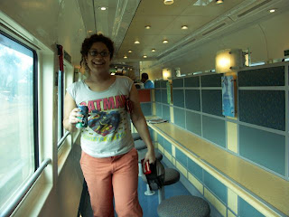
Pam is sober and is on her way to a sugar high


Richard and Anderson are finding something funny


Two-and-half hours later, we arrive at the tiny town of Cardwell. After settling in at a backpacker’s hostel and getting some last-minute groceries for the walk, we spend the rest of the afternoon walking along the beach and generally enjoying the sun.

Day 2: from boat to trail – walk to Nina Bay, 5 km

In the morning, the sun is shining with not a cloud in the sky. It’s going to be a good day for walking. In mid-morning, we are picked up by the minivan to take us to the harbor where the ferry leaves. A hour later, after a quick stop at the resort on the island, we get dropped off at one of the creeks where the walking trail starts. The boardwalk to the beach is closed for maintenance, so the trail starts from a different creek and adds another hour to the walk. Although our packs are at their heaviest, we are all fresh and our steps are light.

Between Richard, Pam, and Anderson, there are three bum knees and one previous ruptured Achilles tendon. Ironically, being the oldest one in the group, I am the only one without any previous musculoskeletal injury. The Thorsborne Trail, deceptively short at only thirty-two kilometers in length, is considered a difficulty one due to the terrain. Rock hopping, swamp wading, creek crossing are all part of the deal. While they may not be that difficult on their own, put twenty-five kilos of pack on your back and the challenge is not hard to appreciate. So we will take it slow.

Looking back at Port Hinchinbrook as the ferry pulls away


Jagged peaks form the skyline of Hinchinbrook


Our party of four: still smelling fresh, our clothes still clean, and our muscles still loose


The ferry cruises up one of the creeks lined with mangroves. Mt Bowen looms in the distance.


The temporary disembarkation site: just a couple of planks tied to mangrove roots, an apt introduction to the walk.


Walking down Ramsay Bay


We want to have lunch at a place with a view, so we walk to up Nina Peak via a side trail. At 312 meters elevation, Nina Peak offers spectacular views of the Island, with Ramsay Bay and the numerous channels to the north and Nina Bay, Little Ramsay Bay, and Zoe Bay to the east and south. After a few reconnaissance missions, we find a rock ledge in the shade, perfect as our lunch spot. One by one, we slide up the ledge. With our feet hanging over the edge and a couple of hundred meters sheer drop just inches away, we start making our lunch of salami and cheese wrap. Away from the midday sun, with an awesome view of the bays to the south, Mt Bowen directly to the west and sheer rock directly under us, it’s hard to imagine a better place to have lunch.

Richard, Anderson, and Pam taking a break


View of Ramsay Bay and the channels snaking their way into the island


Lunch spot with Mt Bowen in the background


The view from our lunch spot


After lunch, we reluctantly leave our awesome lunch spot and head back down to the trail. An hour or so later, we arrive at our camp site at Nina Bay. The hammock I got for my cycling trip in New Zealand comes in handy again. I string up my hammock while the other guys pitch their tents right on the beach.

Hammock is the way to go, as long as there are trees to string one up.


At night, we cook a filling meal of instant soup, followed by rice with curry, then tea with roasting marshmallow over an open fire. We sit on the beach under the full moon, chatting away until late and not worrying about disturbing anyone – we are the only group at this campsite for the night.

Day 3: Nina Bay to Little Ramsay Bay, 2.5 km

After a good night of rest, we get up as the sun comes over the horizon. After some hot tea to warm ourselves up, we have a yoga session led by Pam the Yogi right on the beach.

The sun peeks over the Coral Sea


Anderson staring at the rising sun


I need to work on my warrior pose


After a leisurely breakfast and getting our water bladders filled, we set off for a short walk to Little Ramsay Bay.

Anderson says, “Let’s get crackin’!”


View of Nina Bay from the rocky headlands


Richard picks his way through the pile of rocks at Boulder Bay


We arrive at Little Ramsay Bay before lunch time. After setting up camp and eating another lunch of salami and cheese wrap, we head to the lagoon for a quick dip.

Anderson walks down Little Ramsay Bay toward the campsite amongst the bush


Pam is out cold in the hammock


Day 4: Little Ramsay Bay to Zoe Bay: 10.5 km

We wake up to another day of beautiful weather. Today is the longest walking day, so after a quick breakfast, we pack up camp and head off towards Zoe Bay, 10.5 kilometers to the south. En route, we will climb over rocks, cross a couple of swamps and creeks.

The lagoon at Little Ramsay Bay in the morning with Mt Bowen dominating the skyline


Anderson and Pam gathering water before the day’s long hike


The beach at Little Ramsay Bay ends at this pile of rocks we have to climb over


The view north from the rocky headland


Walking sticks are essential for this trail


We are standing at the saddle between Banksia Bay and Zoe Bay. Zoe Bay is the sliver of blue at the base of the mountain in the distance.


Crossing one swamp with slippery tree roots


Crossing North Zoe Creek. The water may not be deep, but the rocks are very smooth and slippery.


Crossing a palm swamp with ankle-deep mud. A couple of days ago someone fell while hopping from tree root to tree root. He ruptured his Achilles tendon and had to be airlifted out. So, be very careful and just step right into the mud. Better be dirty than be hurt.


We pass another mangrove swamp, which is dry enough that we can walk around it.


With another hour of sunlight to spare, we arrive at the campsite at Zoe Bay. A sign warns us of the crocodiles active in this area. After dinner, we set up another fire on the beach damp from dews. The temperature is dropping more than previous nights. We huddle around the fire, drying our boots and socks that were completely soaked from earlier in the day, and chat late into the night.

We collect our drinking water from South Zoe Creek, just downstream from Zoe Falls.


South Zoe Creek in at dusk, with the sounds of rushing water and chirping birds, is quite the tranquil place to be.


Day 5: Zoe Bay to upper Zoe Falls: 1 km

Today’s goal is to walk to Sunken Reef Bay, with a stop at the base of Zoe Falls.

The dampness on the beach evaporates as the sun comes up over Zoe Bay


The sound of Zoe Falls gets louder and louder as we walk up along South Zoe Creek. As we round a bend on the trail, the waterfall comes in full view. What a welcoming sight: a natural rock pool at the bottom of the cascading falls with crystal clear water flowing through. Add the bright sun and blue sky, we can spend all day here!

The picture-perfect Zoe Falls


After a little asthma attack, Pam makes it to the bottom of the falls and is rewarded with the best water massage.


After the invigorating swim and water massage, we sit on the rocks to admire the view. Eventually, we decide that we would have to make a move if we were to make it to camp before nightfall. Reluctantly, we put our packs back on and follow the trail up to the top of Zoe Falls.

Anderson pulls himself up on this steep section


A ten-minute walk takes us to the top of Zoe Falls. Zoe Falls may be nice, but the view up here is amazing! We look around, and come to the simultaneous conclusion that we have done enough walking today. We will set up camp here and spend the whole afternoon on these rocks. The water has carved numerous tubs into the rocks. We decide this is our spa day. Jump into this one for a soak, get into the next one for a shoulder massage, lay on the warm rocks to dry out, back to step one and repeat as needed. This is the best decision we have made.

With a view like this, it’s hard to keep moving.


Just whiling away the afternoon


Richard is enjoying a world-class shoulder massage.


Another view of the pools with Zoe Bay in the distance


In the late afternoon, I go back to the bottom of Zoe Falls to take more pictures of the creek.


Zoe Falls at dusk


The low-light condition at dusk is perfect for taking pictures of moving water.


At night, we set up our stoves on the warm rocks and cook up another satisfying meal of mapo tofu over rice.


Day 6: upper Zoe Falls to Mulligan Falls: 6.5 km

In the morning, clouds start to roll in from the east. It looks like rain is a definite possibility today. We will skip Sunken Reef Bay and head straight to Mulligan Falls.

Breakfast on the rocks


Rich and Pam negotiating their way down rocky steps


As we stop for lunch, rain starts to come down. Although it passes quickly, the trail is quite slippery now. After a quick break, we press on.

From this point, the mainland to the south is visible, with the long jetty from Lucinda cutting across the water.


The rain makes everything that much greener


Walking past the side trail leading to Sunken Reef Bay, we come upon the mighty Diamantina Creek. These creeks can swell up fast after the rain and signs are there to warn walkers of the danger of crossing one right after the rain. We check the condition of the creek and the water level on the rocks and decide to cross. With every rock carefully selected for foot hold and every step carefully tested, the going is slow.

Contemplating the creek crossing


Following the arrows on the rocks, we start to cross the creek.


It may look like a tranquil picture, but the rocks are very slippery, especially after the rain.


After crossing Diamantina Creek, it’s only another half-hour to the Mulligan Falls campsite. We set up camp, and it’s time for another swim. Despite the overcast sky and slightly cooler temperature, the swim is still refreshing.

Waterfall and rockpool, the winning combination


Mulligan Falls at dusk


As we finish dinner, rain comes down again. We abandon our gear on the ground and quickly get into our tents. Swinging in my hammock, dry and toasty in my sleeping bag, I am soon fast asleep as the rain hits the rainfly just above me.

Day 7: Mulligan Falls to George Point: 7.5 km

Sadly, this is our last day on the island. The rain has stopped. We eat a leisurely breakfast while waiting for things to dry out a bit. All we have to do is walk to George Point 7.5 kilometers away, most of it along the beach. Easy day.

We gather around the spread of water bottles and stove for breakfast. Our packs and food are hung up on ropes to prevent the native rats from getting to them.


The walk out to the beach takes us through a forest reminiscent of Lord of the Rings country, with sprawling tree roots winding among rocks.


The walk on the beach is so easy compared to the rest of the trail, it almost gets a little boring. With our shoes off, we wander down towards George Point. Without having to worry about where to put the next step, all there is to do is to listen to the waves on the left and admire the cloud-covered peaks on the right.

Crossing Mulligan Creek with Mt Straloch in the background


The ragtag army strolls down the beach


We made it to George Point!


From George Point, another boat takes us back to the mainland. And our walk on Hinchinbrook comes to an end.

Looking back at Hinchinbrook from the boat to Lucinda


From Lucinda, a minibus takes us back to Cardwell. We check back into the backpacker’s. First order of business is showers! Throwing on some semi-clean clothes, we celebrate the completion of an awesome walk.

Cheers!


Day 8: Cardwell, Cairns, and back to Brisbane

To get back to Brisbane, we catch a bus from Cardwell to Cairns, 180 kilometers to the north. After an afternoon of walking around the tourist district of Cairns, we catch a late-afternoon flight back to Brisbane.

Our trip comes to an end. This may be the last time in a long time that the four of us would be able to make a trip like this. In six months, we will graduate from med school and will head our separate ways; and we may be scattered all over the world.

But guys, remember what I mentioned on the trail – cycling the Silk Road, 2012.